
Site and Location Overlays for Portland Listings: When Aerial Context Helps
Late September changes the view from above. Maples start to turn along Portland streets, the first rain darkens the pavement, and an aerial frame can show a property's relationship to its lot more clearly than a ground-level photograph ever could.
That is where a site and location overlay can help. It adds approximate parcel lines or selected location markers to one aerial image so the viewer can understand what belongs to the property and what sits nearby. The useful question is not whether every listing should have one. It is whether a labeled aerial answers an important question faster and more clearly than the rest of the media plan.
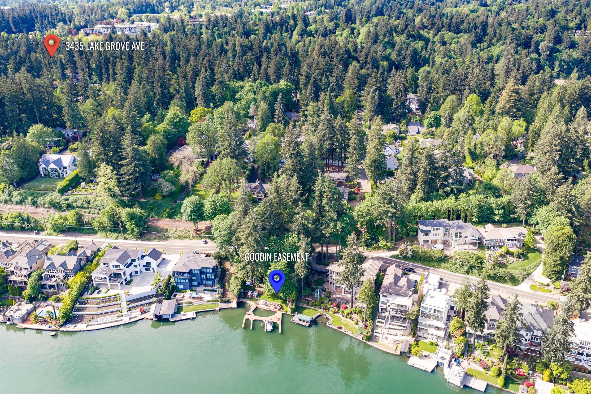
What Site and Location Overlays Actually Do
A site and location overlay begins with a professionally selected aerial photograph. We add approximate property boundaries, an arrow when orientation needs help, and labels for relevant landmarks. Our add-on includes an MLS version focused on parcel lines and public landmarks, plus a marketing version that can identify nearby shopping, dining, and other destinations outside the MLS.
The image is not a survey, a title report, or a promise about a legal boundary. Metro's regional mapping tools make that distinction directly: tax lot boundaries are useful for orientation, but they are not exact property lines. We treat the overlay the same way. It is a visual guide built from available parcel data and the aerial frame, with wording and placement kept clear enough that the graphic informs rather than overstates.
This is why the overlay belongs inside a complete media set. Photography shows the interior and exterior experience. A floor plan explains the rooms. A Zillow 3D Tour or Matterport model lets someone move through the layout. Drone photography establishes the setting. The overlay adds labels where they make that setting easier to read.
When Site and Location Overlays Are Worth It
1. The parcel shape is hard to understand from the street
A long driveway, flag lot, corner parcel, or irregular boundary can be difficult to read in standard exterior images. From above, the geometry becomes visible. An approximate outline can show how the residence, yard, detached garage, and access relate.
2. More than one structure belongs to the property story
A main house with an ADU, guest house, barn, studio, or workshop often needs a wider view. Additional Building Coverage gives each structure its own interior and exterior photographs; the overlay then helps orient those buildings on the site.
3. A public landmark provides useful context
Proximity matters when it is specific and verifiable. A trail entrance, public park, river access point, school, or transit stop may be easier to understand when it is labeled on the aerial. RMLS guidance allows lot lines, road names, property-identifying arrows, and names of public amenities when they are not misleading or otherwise in conflict with its photograph rules. We keep the MLS version restrained and leave private businesses to the marketing version.
4. The land and access matter as much as the house
For a larger parcel, the driveway, tree line, open area, slope, and relationship between buildings may be central to the listing story. Extended Acreage Coverage provides the additional aerial and ground views. A single overlay can then serve as the orientation frame near the beginning of a property website, brochure, or gallery sequence.
5. The agent needs one image that explains location quickly
Sometimes the clearest use is outside the MLS. A marketing overlay can support a property website, email, listing presentation, or social post by showing the home in relation to a commercial district, river corridor, or cluster of everyday destinations. A North Portland listing near the bluff and a Lake Oswego home near the water may both benefit, but the labels should be chosen for the actual property.
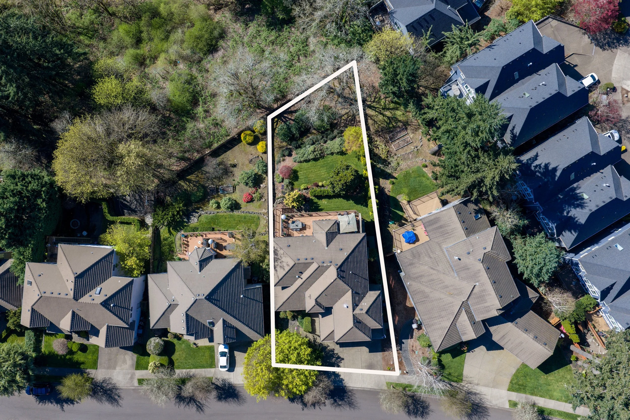
When an Overlay Needs Restraint
An overlay works best when it resolves a real question. There are also several situations where the clean aerial image should remain the lead.
1. Labels compete with the property
A good overlay has a short job. Too many callouts turn the photograph into a crowded map and pull attention away from the home. We choose only the boundaries or landmarks that help with orientation, keep the typography readable, and preserve enough open image area for the aerial itself to do its work.
2. The standard media already answers the question
A straightforward subdivision lot may read perfectly in professional photography, aerial coverage, and a floor plan. In that case, an overlay can repeat information without adding much. The budget may be better used on natural twilight, editorial detail images, virtual staging, video, or a 3D tour, depending on what the listing needs to communicate.
3. The intended channel has different rules
The MLS and an agent's broader marketing channels are not the same surface. Public-landmark labels may fit the MLS version, while restaurant or shopping names belong in the marketing version. Rules and third-party rights can change, so the agent remains responsible for confirming how the final image will be used. We can prepare the two versions so that distinction is clear.
The Strategic Question to Ask
“What important fact about this property becomes immediately clearer when we label the aerial?”
If the answer is the parcel shape, shared approach, relationship between buildings, access point, or proximity to a public amenity, the overlay probably has a clear role. If the answer is simply that the image looks more elaborate, the clean aerial may be stronger. More information is useful only when it improves orientation.
We also look at the question in sequence. If the listing first needs strong interior and exterior coverage, we start there. If layout is the challenge, a floor plan or 3D tour may do more. If the setting is the challenge, aerial photography and an overlay can work together. And because commercial drone work operates under FAA rules and local airspace conditions, we confirm what can be captured safely before building the graphic around a planned angle.
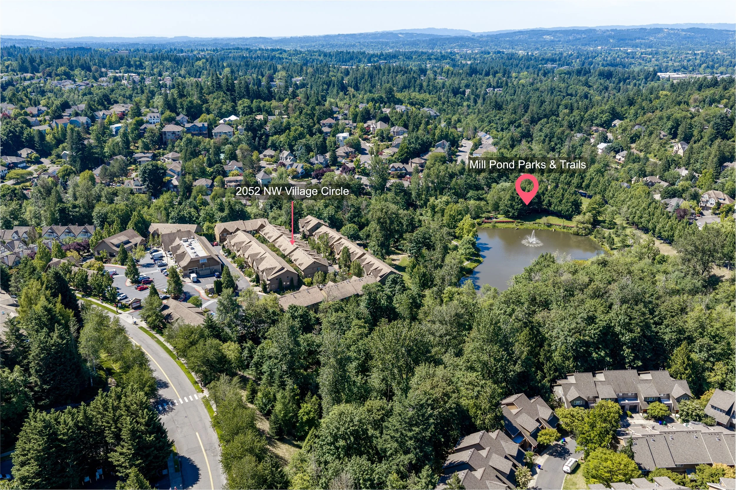
Final Thoughts
Portland-area properties often make more sense when we can see beyond the front elevation. Hills, tree cover, irregular streets, detached structures, trails, and water all shape how a site reads. A careful overlay can turn that wider view into a useful piece of listing communication without asking the image to stand in for a survey or a legal document.
It is a focused add-on, not a default layer for every home. Some listings need only clean aerial coverage. Others benefit from approximate parcel lines, a few public-landmark labels, or a separate marketing version that connects the property to the places around it. The right choice comes from the question the listing media still needs to answer.
If you have a Portland or Southwest Washington listing where the lot, access, additional buildings, or location needs clearer context, we are happy to talk through it on a quick call. We can decide whether a site and location overlay belongs in the plan, which version fits each channel, and how it pairs with photography, drone, floor plans, 3D tours, twilight, or video. Current package and add-on pricing is available below.
